|
0 Comments
PNWAS ZOOM Meeting Thursday December 9th 2021 starting at 6:30 with program at 7:00 PM To join the ZOOM Meeting and see the presentation please become a member today! Late-Glacial Hunter-Gatherers in the Central Alaska Range and the Role of Upland Ecosystems in the Peopling of Alaska By Dr. John C. Blong, Washington State University Upland central Alaskan ecosystems are typically thought of as less productive and more challenging for humans to live in than lowland ecosystems. It can also be difficult to conduct archaeological research in high-elevation locations. Because of these issues, archaeological research often prioritizes investigations in the lowlands. However, Alaskan upland ecosystems can provide novel resources that attract human activity. With increased research focus in recent years, archaeologists are pushing back the earliest evidence for human activity in upland ecosystems around the world. This is also the case in central Alaska, where there is growing evidence that the earliest humans to settle eastern Beringia during the late-glacial period made use of subsistence and lithic resources in the central Alaska Range. In this presentation I review the late glacial paleo-ecological and archaeological record of the central Alaska Range, highlighting its role in hunter-gatherer land use during the initial settlement of eastern Beringia. The early use of upland landscapes in Alaska suggests variability in land-use patterns during the initial settlement of North America and has significant implications for our understanding the process of the first peopling of the Americas. 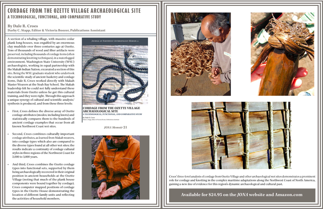 PNWAS ZOOM Meeting Thursday October 7th 2021 starting at 6:30 with program at 7:00 PM To join the ZOOM Meeting and see the presentation please become a member today! Ancient Northwest Coast Cordage and Knots by Dale R. Croes, Ph.D., WSU/PNWAS (with release of new book, see link below or search Amazon and I can sign at PNWAS campout in August, since hard to do on ZOOM) The “brother” to basketry, I have just published a 40-year update on ancient CORDAGE and KNOTS on the Northwest Coast of North America, with a focus on the 2000+ examples from the Ozette Village wet site. As one of the most common artifacts from Pacific Northwest wet (and shell midden) sites, cordage and knots play a key part in the dynamic Maritime Societies for over 10,000 years along the coast and riverways. As will be seen, ancient cordage (and knots) on the Northwest Coast were some of the most common artifacts, often hundreds and sometimes thousands in most NW wet site excavations. Cordage was basic to the complex Maritime Societies on the Northwest Coast of North America, from whale harpoon cedar bough twisted ropes, to spruce root string nets to cedar bark string warps wrapped with bird skins strips with down adhering to make thick warm blankets. Though we cannot have a book signing for this new Cordage book through ZOOM, let me know if you buy one and I will send a personalize signing to insert in the book. Thanks, Dale ([email protected] ) 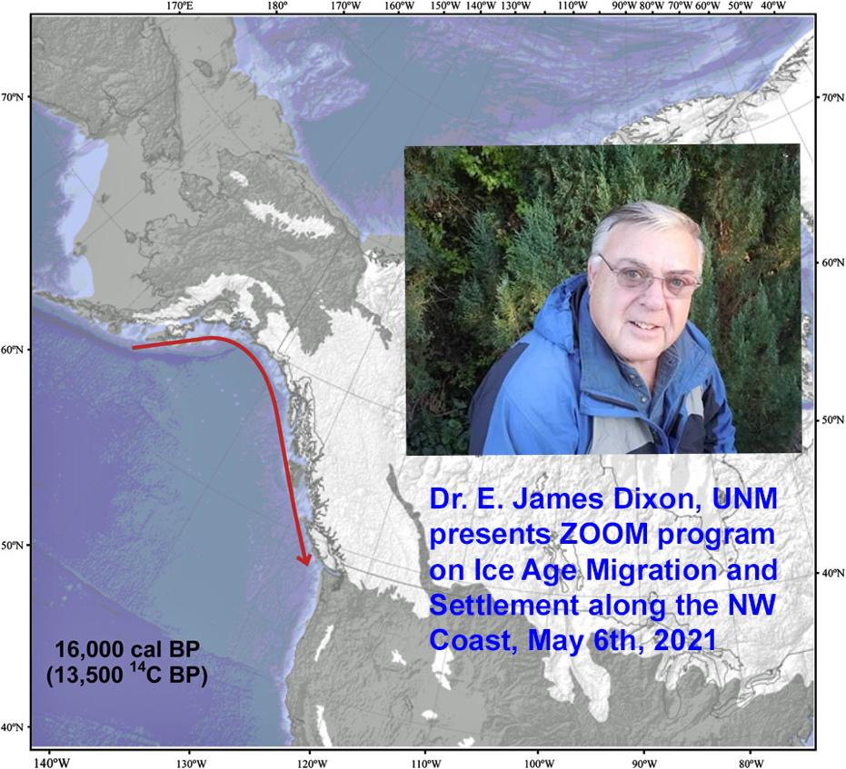 PNWAS ZOOM Meeting Thursday May 6th 2021 starting at 6:30 with program at 7:00 PM To join the ZOOM Meeting and see the presentation please become a member today! Ice Age Migration and Settlement along the Northwest Coast of North America By Dr. E. James Dixon, University of New Mexico Archeological and genetic evidence indicates that people first entered North America from northeast Asia sometime during the last ice age, or late Pleistocene, at least 16,000 years ago, or possibly earlier. During the last glacial maximum (LGM) circa 18,000 years ago, sea level was approximately 120 m (about 390 ft) lower than it is today. As a result, the Bering Land Bridge and continental shelf of the Northwest Coast of North America created a continuous shoreline stretching from Northeast Asia to Southeast Alaska. Geological and archeological evidence suggests that this coastal corridor was ecologically viable and capable of supporting human groups and was the earliest ice-free pathway available for people to colonize the southern regions of the Americas. Following the LGM the climate changed rapidly resulting in: 1) sea level rise that flooded the Bering Land Bridge and severed the land connection between Asia and North America, 2) sea level rise along Alaska’s Northwest Coast forced a landward retreat of people living along the coast in response to rising sea level, and 3) the newly deglaciated land provided new opportunities for people to move landward and colonize terrain recently exposed by melting glaciers. Makahs, Quileutes, and the Precontact History of the Northwestern Olympic Peninsula, Washington3/5/2021 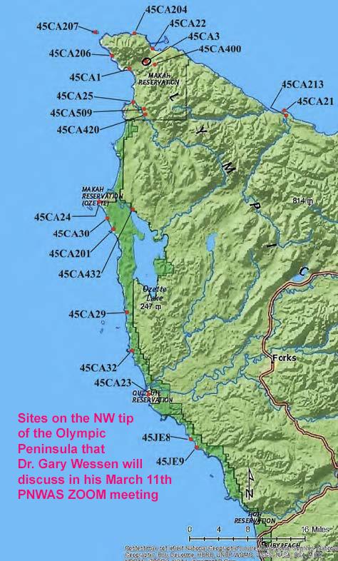 PNWAS ZOOM Meeting Thursday March 11th 2021 starting at 6:30 with program at 7:00 PM To join the ZOOM Meeting and see the presentation please become a member today! Makahs, Quileutes, and the Precontact History of the Northwestern Olympic Peninsula, Washington By Dr. Gary Wessen, Wesson and Associates, Inc., Port Townsend Variations on the related ideas that: (a) the Makah people arrived on the northwestern Olympic Peninsula of Washington as recently as 1,000 years ago and (b) they displaced Quileute people who had previously held those lands have appeared on a few occasions during the last century. As offered, such claims rely heavily on ethnographic and linguistic arguments. A detailed examination shows that all of these arguments are flawed. The currently available archaeological data is not sufficient to address these ideas in an unequivocal way but may still offer relevant insights. Doing so, however, requires some ability to recognize these groups in the archaeological record; this possibility is explored using the artifact and faunal assemblages from this region. Preliminary findings suggest that Makahs and/or other Wakashan speakers have been present for at least 3,000 to 4,000 years and that there is no credible evidence for an earlier presence of Quileutes and/or other Chimakuan speakers. This ZOOM presentation examines some existing ideas about the late precontact culture history of the northwestern Olympic Peninsula of Washington (see map, above). The area under consideration includes the coastal margins of the traditional territories of two neighboring groups: the Makah and Quileute peoples. For the most part, it consists of exposed, steep, rocky shorelines marked by numerous nearshore rocks and small islands (see photos). Low, sandy beaches occur in some places, but they are often small. Terrestrial surfaces farther inland are mostly steep and heavily forested. On the north, a few small coastal river valleys break up this pattern. Farther south, the much larger Quillayute and Hoh Rivers reach the ocean on relatively broad alluvial flats. PNWAS ZOOM Meeting Wednesday, January 6th 2021 starting at 6:30 with program at 7:00 PM To join the ZOOM Meeting and see the presentation please become a member today! Occupying the American Continent through SW WA.-- the Chehalis River Hypothesis (CRH), Or Hey, Where did those First Migrants Go? Animated Video By Victor J. Kucera, Co-Author, CRH, Arizona Co-author of the Chehalis River Hypothesis (CRH), Vic Kucera, Author, Arizona, has produced a video discussing our American-Continent-entry hypothesis with animation and narrative. Though done a few years back, it remains up-to-date, and features the work at Paisley Cave, Oregon and aspects of the Chehalis River drainage floods discussed in our recent PNWAS ZOOM programs. Vic particularly explores the Who, When, and particularly HOW people initially moved into the whole American Continent through the ancient Chehalis River Drainage. Dr. Dennis L. Jenkins, Senior Research Associate II Director, Northern Great Basin Archaeological Field School, Museum of Natural and Cultural History, University of Oregon PNWAS ZOOM Meeting Thursday, November 12th, starting at 6:30 with program at 7 pm Archaeology and Science at the Paisley Caves, Oregon: Evidence of People in our region 14-15,000 years ago By Dr. Dennis L. Jenkins, University of Oregon Listen and ask Dr. Jenkins about his illustrated ZOOM presentation providing evidence for the association of humans and Pleistocene animals more than 14,000 years ago and how this supports our Chehalis River Hypothesis. Dating of artifacts, camel and horse bones, and dried human feces containing Native American DNA, bile acids, sterols, hair, and protein residues between 12,900 and 14,500 years ago indicates that people lived in the SE Oregon caves and consumed mammoth, camel, horse, mountain sheep, deer, pronghorn antelope, rabbit, small mammals, fish, birds, and insects. This colorful slide show takes the audience through the scientific processes involved in proving the case for pre-Clovis (>13,500 years) human occupations at the world-famous Paisley Caves in south-central Oregon. If a current member (2020 and now 2021), you will get an invitation to join the ZOOM meeting through an e-mail shortly before the talk (e-mail [email protected] to see if you are current for 2020 and/or 2021, thanks). Hope all going ok in these trying times. We are changing our PNWAS format and will have presentations on ZOOM in the future. Please be sure your membership is current for 2020 so you get to continue to enjoy these talks from home (see attached membership form and you can pay on PayPal). We are continuing with our theme on the Chehalis River Hypothesis (CRH), proposing the first entrance into the entire American Continent was down the coast until eventually reaching our area and the ice free Chehalis River drainage (I am attaching member Vic Kucera and my publication on this CRH so you can refresh this proposed hypothesis for the talk). Together we can explore testing this hypothesis with different specialists in our region. The foremost Geologist in our region is Professor Pat Pringle, who will present the following presentation the evening of Thursday, September 24 at 7pm. You'll need to provide your own coffee/tea/hot coco/cider (maybe wine/beer) and treats since we sadly will not be at the Mountaineers in Seattle. If you are an updated member (2020) you will receive an invitation to join us via email in the near future (so signup and help us) and here is a ZOOM tutorial: https://www.youtube.com/embed/hIkCmbvAHQQ?rel=0&autoplay=1&cc_load_policy=1 Here is our first CRH Program (see attachment with color map and description below): Thursday, September 24th, at 7 pm, starting PNWAS Meetings on ZOOM The Late-glacial Tanwax Flood and Debris Flow—An Ice-Age Flood from the Cascade Range into the Puget Lowland and Likely Source of Sediments for the Mima Mounds By Pat Pringle, Research Geologist, Professor Emeritus of Earth Sciences, Centralia College The Puget Lobe of the Vashon Glacier blocked the Carbon River at the time of the last glacial maximum about 17,000 years ago. A large lake filled the Carbon River and adjoining areas of the ice margin. Sometime later the lake level dropped by more than 50 meters as indicated by the levels of existing kame terraces, releasing a large flood of water that carved into sediments of the Puget Lowland creating and deepening the Tanwax, Ohop, and other valleys. The flood also triggered a number of landslides that transformed into debris flows whose equivalent deposits can be traced more than 100 km flow distance to the west. Equivalent deposits (rich in andesite) can be found in Rocky, Violet, Mima, and Ford Prairies, Tenino, and the Skookumchuck and Chehalis River valleys. The flood merged with outwash from the Puget Lobe in the Black River Valley and continued downstream in the Chehalis River. Both the flood and discharge from the Puget Lobe into the Chehalis River modified the landscape of the southernmost Puget Lowland and Chehalis River. Although the floods of water would have posed a temporary obstacle to movement of people, the prairie landscapes left behind proved favorable for human use and travel. [this is based on work Barry Goldstein of University of Puget Sound (UPS) and I have done over the past 20 years] Future programs will present the result of TESC student, Christina (Jellyfish) Gomez, who got a student grant to visit and record mammoth/mastodon and other megafauna remains at regional museums. Her illustrated presentation will show examples of these megafauna remains in our region. We also have a PNWAS grant through the Squaxin Island Charitable Fund (1%) to C14 date the mammoth/mastodon bones of interest she finds (hopefully with cut marks!). So we will send an update, inviting members to begin joining us on ZOOM to brainstorm these ideas and test our hypotheses through our Society. Thanks and see you soon [zoom], best to all, Dale PS if you are not sure if you are up-to-date on membership, let me know, and thanks for help at this time, Dale 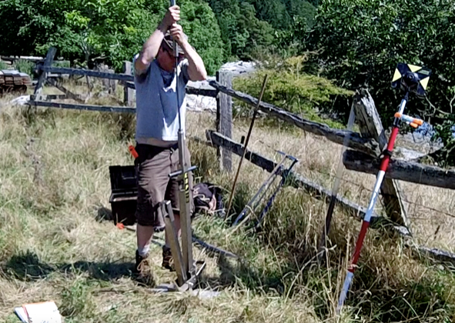 Taking the samples from a long house depression on Galiano Island, Gulf Islands, Vancouver, B.C., Canada. Where were all the Villages? Applying Geophysical Prospection to Understand Long-term Household and Community Dynamics in the Salish Sea By Dr. Colin Grier, Department of Anthropology, W.S.U. Vancouver Despite decades of archaeological survey, CRM work, and targeted excavation inside houses, the sample of documented precontact Salishan house and village plans — and even simply village locations — remains surprisingly limited. As a result, many questions about household and village dynamics over the short and long term remain difficult to address. I outline how geophysics and archaeological ground-truthing can be productively applied to this problem, illustrated primarily by recent and ongoing research in the southern Gulf Islands of British Columbia. I also lay out some long-standing and emerging hypotheses concerning household and village organization, and how addressing these can serve the goal of restorative justice and reconciliation for Indigenous peoples of the Pacific Northwest. As highly perishable wooden constructions, plankhouses appear in the archaeological record of the Northwest Coast primarily through their footprint – as house terraces, platforms and depressions. Few of these house features have been preserved given modern coastal development, but the Dionisio Point site (DgRv-003) on Galiano Island provides an important example of the extent of terraforming that occurred to produce large houses and villages. At Dionisio Point, at least five house features were established around 1500 years ago on three terraces that were cut into a sloping hillside. These three terraces measure approximately 60 x 20 m. The middle terrace contained a plankhouse estimated at 40 x 10 m in size, and the upper and lower terraces contain two houses each that measured approximately 20 x 10 m. The houses were laid out in a systematic and regular fashion suggesting an overall plan to the village, and radiocarbon dates indicate contemporaneity of the five known houses. Houses on the terraces are surrounded by 1 to 3 m high earthen ridges, adding to the engineered design of the village location. Terraforming at Dionisio Point illustrates an impressive and substantial effort to clear trees, excavate terraces, move earth and construct massive plankhouses. DATE: Friday, February 21st, 2020 TIME: 7 pm to 9 pm PLACE: Mountaineers Seattle Program Center, 7700 Sand Point Way NE, Seattle, WA 98115 in the Cascade Room COST: FREE to members, $10.00 to non-members, $5.00 for Students (please renew membership for 2019 and these programs at http://www.pnwas.org and now through PayPal) Refreshments provided (Please bring cookies/snacks to share with the beverages). 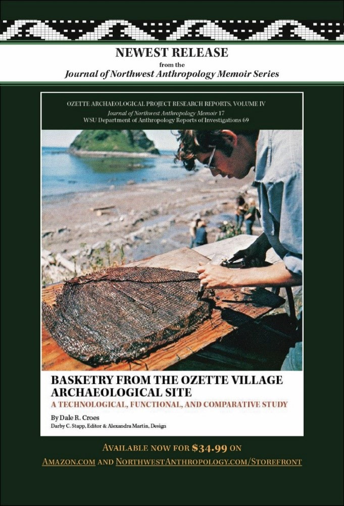 A book signing and cake on the just released edition of: Basketry from the Ozette Village Archaeological Site By Dr. Dale R. Croes, W.S.U. and PNWAS Director From the Editor, Dr. Darby Stapp: When Dale Croes asked us to consider publishing Basketry from the Ozette Village Archaeological Site: A Technological, Functional, and Comparative Study, the decision was easy. Written 50 years ago to fulfill the dissertation requirement for Dale’s Ph.D. at Washington State University, it was scheduled to be published as Volume IV of the Ozette Archaeological Project Research Reports. But, for various reasons it never did appear, and the basketry information from this important site remained largely inaccessible. Remarkably, however, for the past 50 years, Dale has continued researching Northwest basketry, building on the incredible dataset that launched his career by excavating and analyzing basketry from wet sites across the Pacific Northwest. The vision he described to us was a document that would keep the integrity of the original dissertation intact, but supplemented with new information—in the form of footnotes—from more than a dozen major wet site excavations conducted in British Columbia, Washington, and Oregon. A little awkward perhaps (is there another document in existence with 268 footnotes, 232 figures, 43 tables, and 25 maps?), but in terms of anthropological value, a treasure. How fortunate are the tribal and archaeological communities to have a major synthesis of Northwest basketry written by one of the few people on earth who could produce such a synthesis. When it comes to anthropological value, it doesn’t get much better than that, so our reply to Dale was an emphatic, “Yes, we would be honored to publish Volume IV of the Ozette Archaeological Project Research Reports.” DATE: Friday, December 20th, 2019 TIME: 7 pm to 9 pm PLACE: Mountaineers Seattle Program Center, 7700 Sand Point Way NE, Seattle, WA 98115 in the Cascade Room COST: FREE to members, $10.00 to non-members, $5.00 for Students (please renew membership for 2019 and these programs at http://www.pnwas.org and now through PayPal) Refreshments provided (Please bring cookies/snacks to share with the beverages). |
Archives
January 2022
Categories |
 RSS Feed
